Archeo-Astrology is a technique of charting the future or past sky using a scientific tool. This tool helps to arrive at planetary positions given a date in future or past and vice-versa i.e. given a set of planetary configurations, arrive at the date either in future or in the past. Such tools are collectively called Planetarium software. There are probably over 50 such different software available. Each software can be used specifically for a particular application, like, plotting the current night sky chart, predicting eclispes and the likes.
When spacecrafts are launched to visit far-off planets like Jupiter and Saturn, it would take a travel time of well over 12 years for the spacecraft to reach these planets. This software helps determine orbital positions of the planets when the spacecraft reaches their orbits. For this, a high level of precision is required in the software.
Unlike any other civilization so far, the literature of the Indian civilization is characterised for being embedded with night sky observations. Feeding the observations of the planetary configurations into the Planetarium software gives us the English calender dates when these configurations could have occured in the past. When these dates are logically arranged along with the events, it helps us to scientifically assign dates to events mentioned in Indian legends and historical texts, and validate them.
Thus the astronomical remains left behind in our literature can be analysed scientifically to arrive at historic dates for various events. This approach is parallel to archaeology where physical remains are analysed to arrive at historic dates and hence gives rise to a new branch of scientific dating which may be called Archaeo-astronomy.
Various modern day researchers have made use of this software to arrive at such historic dates for various events described in the Indian literature. We have collated the outputs of such credible work which are worthy of standing up to cross validation.
In the context of the Historicity of Rama, the works of Shri. Pushkar Bhatnagar, as brought out in the book "Dating the Era of Lord Ram" form the basis of what is presented here to understand the dates of the events in Rama’s lifetime.
Sri Ram Navami - Birthday
Sri Rama Navami is the birth day of Rama
Rama was born on the Navami tithi of Shukla Paksha of Chaitra masa
(9th day of the increasing phase of the moon in the lunar month of Chaitra).
At that time, the nakshatra was Punarvasu, and Sun, Mars, Saturn, Jupiter and Venus were in Aries, Capricorn, Libra, Cancer and Pisces respectively. Lagna was Cancer and Jupiter & Moon were shining together. -- Ramayana 1.18.8,9 |  |
|
|
Sri Rama Navami - 10th January 5114 BCE - Birth Day of Rama
at 12.30 p.m. |
Birth of Bharatha
The Sky Chart of Bharatha's birth is depicted on the right.
This is about 16 hours after birth of Rama.
Birth of Bharatha - 11th January 5114 BCE, 4.30 a.m. | |
Pre coronation eve
 | King Dashratha to his courtiers -
"This month of Chaitra is beautiful and holy. The woods and trees are full of flowers. At this time coronation of Rama is most appropriate."
-- Ramayana 2.4.21-22 |
"Astrologers have told me that my nakshatra has been surrounded by malefic planets like Sun, Mars and Rahu. Under such planetary configurations, the king either dies or falls in some deep conspiracy. Thus, before I face any such problem, you take over the kingship"
-- - Ramayana 2.4.18
"Today the moon is on Punarvasu nakshatra and tomorrow it will meet the Pushya nakshatra. In that Pushya nakshatra, I am eager to hand over the kingdom to you."
-- - Ramayana 2.4.21-22
| King Dashratha with Rama
 |
| 4th January 5089 BCE |
Vali Vadham
| "Hearing the roar of Sugreev, Vali's face became red like the sun caught by Rahu during the eclipse." - Ramayana 4.15.3 |
 |  |
| "Vali Vadham" occured on 3rd April 5076 BCE during the Solar Eclipse, in the Amavasa Ashada during the morning hours. | |
Hanuman's Visit to Lanka
| Hanuman's Visit to Lanka - 12th September 5076 BCE - Lunar Eclipse |
Hanuman's Return from Lanka
| Hanuman's Return from Lanka - 14th September 5076 BCE |
Army march to Lanka
The Vanara Army march to Lanka - 20th September 5076 BCE
Lakshmana's observation : "The Venus has gone to the back side, Sapta-rishi (Ursa Major) are visible brightly, Trishanku (Crux) is visible in front. Moola nakshatra, protector of Rakshasa, is inflicted with Dhumra-ketu (node)." | |
| Internal consistancy of all dates |
Sri Rama Navami - Birth day
Birth of Bharatha
Pre coronation eve
Khar, Dushan episode
Vali Vadham
Hanuman's Visit to Lanka
Hanuman's Return from Lanka
Army March to Lanka
| <->
<->
<->
<->
<->
<->
<->
<->
| 10th January 5114 BCE
11th January 5114 BCE
4th January 5089 BCE
7th October 5077 BCE
3rd April 5076 BCE
12th September 5076 BCE
14th September 5076 BCE
20th September 5076 BCE
| | <->
<->
<->
<->
<->
<->
<->
<->
| | -
1 day
25 years
12 years
6 months
5 months
2 days
6 days
|
It may be noted from the table above that the dates arrived at for the events are not haphazard. They tally with the chronological sequence for the events as found in the Ramayana text. Not only that the elapse times between the events as indicated by these dates also tallies with the elapse-time and duration/age as described in the Ramayana text.
This establishes internal consistency in these dates and proves the credibility of the technique.
Ramayana is geographically very correct
| Every site on Rama's route is still identifiable and has continuing traditions in the form of temples to commemorate Rama's visit. |  |
| In those remote days no author had the travel facility to concoct a geographically credible story and build it into local folklore. |  |
All the places visited by Rama still retain memories of his visit. Some places have commemorative temples, others commemmorate Rama's visit in local folklore.
There is convergence in literature, archaeology and local tradition. | |  |
Dunagiri
 | As per the history we know, in the Lanka war, Lakshmana was mortaly wounded. The Sanjeevani herb was needed to revive him. |
 | Hanuman picks up whole hill of medicinal herbs. | | |
Hanuman brings hill with herbs to Sushena who treats and revives Lakshmana .
Not that well known is the story that, Hanuman then returns the hill to its original place after use, on the same night, before dawn. The boulders, stones, etc. of Dunagiri fell in many places enroute. Hence the complete hill was not returned.
Dunagiri - Uttarakhand: In the Gandha Madhana mountains, now known as Dunagiri, there lies a scar on the side of Dunagiri where Hanuman sliced off a big chunk. In most re-tellings of Ramayana, after the medicines were used, Hanuman flies again to replace the mountain in its rightful place.
| According to Dunagiri local folk lore, Hanuman failed to return full hill. |  |
| Because of his failure to keep up his word local villagers refuse to take the temple prasad at village's annual festival. |  |
 | One of the medicinal plants on Hanuman's list, Visalyakarani, in Samskrit meaning "removing spikes & arrows." - Found in Dunagiri |
 |
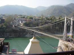
Devaprayag
Ravana – Lankeshwaran
Ravana was: A Shiva baktha, An Exponent of the Vedas, A gifted veena player, played the Sama Veda on veena and A Brahmin
Rama did brahmana vadham prayashchitham, i.e., an atonement for killing a Brahmin, at Devaprayag – Uttaranchal |  |
Devprayag Sangam - Confluence
Alaknanda
Ganga |  |
| Rama performing brahmana vadham prayashchitham |  |
Kishkinda
Kishkinda is near Hampi in modern day Karnataka. Anjanadri near Hospet is the birthplace of Hanuman Anjaneya. Sugriva lived in Rishyamukha on the banks of the Pampa Tungabhadra.

|
In the British records of the gazette of Bellary district, which is very near modern day Hampi, or Kishkinda of earlier times, the then collector has noted that the forest tribes of that area call themselves the Vanara people, and used Monkey as a symbol in their totem pole and flag.
This vanara totem in Bellary District Gazetteer is to the right.
The Jaina Ramayana also mentions a banner of the Vanara, Vanaradhvaja, vanara flag |  |
|
Rameswaram
Rama worshiped Shiva at Rameshwaram and prepared the Linga out of sand.
| 
|

|  |
Bridge
Connection between Adam's Bridge - Rama Bridge

Nobody else in Indian history has claimed its construction
Though Valmiki did not visit the south

Valmiki would know the difference between a sea and a river.
|
Lanka
Ravana Ella Falls - Ravana hid Sita to prevent Rama from finding her

Sitai Amman Temple Numara Eliya Ashokavana - Ravana Kept Sita Prisoner |

 Sethusamudram "Sea of the Bridge". Maps prepared by a Dutch cartographer in 1747, available at the Tanjore Saraswathi Mahal Library show this area as Ramancoil, a colloquial form of the Tamil Raman Kovil (Rama's Temple) Another map of Mogul India prepared by J. Rennel in 1788 retrieved from the same library called this area the area of the Rama Temple Many other maps in Schwartzberg's historical atlas and other sources call this area with various names like Koti, Sethubandha and Sethubandha Rameswaram along with others.Valmiki's Ramayana attributes the building of the bridge to Lord Rama in verse 2-22-76. The earliest map that calls this area Adam's bridge was prepared by a British cartographer in 1804, probably referring to an Islamic legend, according towhich Adam used the bridge to reach Adam's Peak inSri Lanka, where he stood repentant on one foot for 1,000 years, leaving a large
  hollow mark resembling a footprint. Both the peak and